


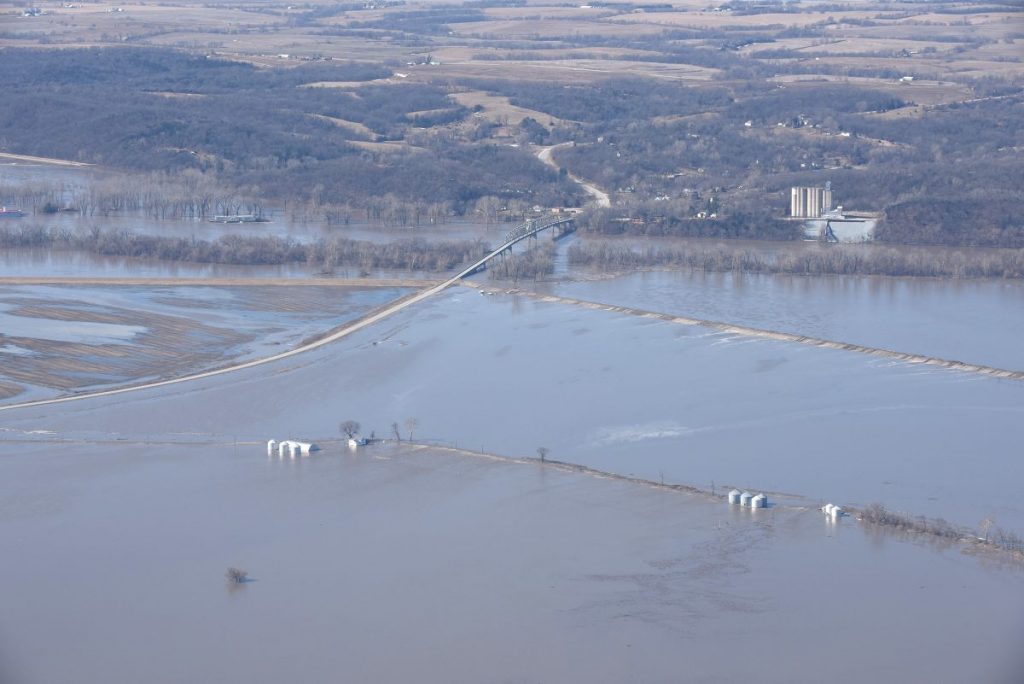
The pictures above and below show the Brownville, Nebraska, flood-ing at Cooper Nuclear Station and the Brownville Bridge. Nebraska Public Power District continues to produce power at Cooper Nuclear Station and is operating at 100 percent. The plant continues to be in a Notification of Unusual Event.

Once again, history is repeating itself and Mother Nature and man are waging a war across the Midwest. From blizzards in Colorado and western Nebraska burying and freezing livestock where they stood, to the worst floods ever in Nebraska, Iowa, and northwest Missouri, excessive amounts of snowmelt and ice jams caused the rivers to rise. Families were displaced, livestock and wild-life were stranded, and entire towns were literally drowned under several feet of water, bringing daily life to a standstill.
We can say it’s 2011 all over again, but in fact that’s not true, as this is actually 100 times worse. River levels across the region have broken previous records, dams that once held back water were completely obliterated by the destructive force of the raging waters, as well as entire roads and bridges, and pieces of ice the size of minivans sliced up roads and were left behind when the waters receded.
As for the immediate area, the water is still here and still taking prisoners. As of the morning of March 17, 2019, there were two confirmed levee breaches in Atchison County: two miles north of U.S. Hwy. 136, approximately a 40 foot full breach; and ¼ mile south of the Watson Boat Dock, approximately 20 foot full breach; as well as other areas of concern from deterior-ation on the levees. Langdon, to Phelps City, to Watson, to Brownville, and all land in between have turned into giant lakes. Even Hamburg, Iowa, which saved itself in 2011 when townspeople built their own levee system keeping out the flood waters that lasted three months (and then later was forced to tear it down by the Corps of Engineers) is now under water. To cruise Main you would have to take a boat. Watson began to flood with water slowly creeping in Monday and by Tuesday morning, March 19, with an added rainstorm, the only road in and out began to overflow with water. Thankfully, a mandatory evacuation had been issued for the Watson area days earlier.
Besides businesses and homes being lost or severely damaged by the unforgiving tide, Missouri Gov. Mike Parsons estimated that 140,000 farm acres are to be impacted. In the days and even hours leading up to the flood, Facebook was filled with pleas by residents looking for assistance with transporting grain from bins that would be under water shortly, or to move as many possessions as possible out of homes that would be flooded just hours later. And it’s not just the people hurting. A video taken during a fly-over shows deer huddled on a tiny piece of dry land that can be seen eroding at the edges by lapping waves. Another video shows two cows who are stranded on top of a very small mound of dirt surrounded by miles of water near Hwy. 111 outside of Craig, Missouri (the farmer is bringing them hay by boat). Two dogs were also rescued from the floodwaters and emergency crews surveying the flood damage planned to keep an eye out for more.
It’s a horrific and sad state of events that to many seem avoidable. After all, we’ve been here before. It’s not floods caused by rain here in our area, but up north. The flooding in our area is due to the excessive release of water by Gavins Point Dam. Starting March 12, Gavins Point Dam was only releasing 18,500 cubic feet of water per second (cfs). However, a catastrophic breach at the Spencer Dam near Spencer, Nebraska, sent the entire backlog of water rushing downstream of the Niobrara River, which connects to the Missouri River 40 miles away. Due to the onslaught of water, the U.S. Army Corps of Engineers decided to increase the release of water at Gavins Point, sending excess amounts of water down the Missouri River headed our way. On March 14, it was increased to 21,100 cfs; March 15 to 56,600 cfs; and March 16 to 90,500 cfs. By then, the damage was done, as levees were topped or breached. Even as the release of water was decreased, March 17 to 73,800 cfs. and March 18 to 54,000 cfs., the water spread out, receded in some areas and took over in others, changed direction, and came back for more. The water makes its own path. The Missouri River beat its previous record level of 44.8 feet by the river cresting at 45.73 feet March 16 (though the river level fell after that it could rise again). Mother Nature can’t be stopped, but we must ask ourselves if during this time of constant rain or excess snow could the levels released at the dam be increased just gradually over many days and weeks and months to hold steady at an amount that does not cause flooding, versus an extra 70,000 cfs. over a few days’ time. It’s not just the Missouri River causing problems. It’s connecting rivers, such as the Nishnabotna, which topped its banks and nearby levees. Monday morning, March 18, there was a confirmed breach on the Nishnabotna affecting Watson from the east.
In the meantime, those not directly affected by the floods are trying to do all they can to help. Atchison County Community Services and Tarkio/Westboro Ministerial Alliance are sponsoring a drive for flood victims in Atchison County and Holt County. On Wednesday, March 20, Community Services in Tarkio will be collecting the following items: good clean towels and sheets, good clean clothing, gift cards, water, cleaning supplies, hangers, laundry baskets, buckets, hygiene products, grocery items, household items (no decor items), paper products, and monetary donations. Times for drop off are 9:00 a.m. – 3:00 p.m. at 322 Main Street in Tarkio. If you cannot make it during this time, please call Shyann Ray at 660-736-4646 to make arrangements or mail checks to P.O. Box 103, Tarkio, MO 64491. Checks can be addressed to Ministerial Alliance or Community Services. Furniture can be donated by calling Shyann to make arrangements for pick-up. A temporary housing shelter for residents escaping the flood has been set up at Rock Port United Methodist Church. Even individuals in and around Atchison County are offering up their homes to shelter those in need. Ella & Grey in Rock Port is donating 20% of all purchases made this week to flood victims.
The Salvation Army is accepting donations for Atchison County. Please mail your donations to: Atchison County Salvation Army, 218 S. Maple, Tarkio MO 64491. You can also go online and donate (be sure to add Atchison County MO). If you have a need, please call 660-736-4212 or contact one of the following board members: Tarkio – Janene McEnaney, Tammy Grossman, Monica Bailey, Sally Wehmann; Rock Port – Jim Clodfelter, Carol Herron, Cathy Davis; Fairfax – Bob Alldredge, Bill Slaughter; and Westboro – Chris Stevens.
The floods also caused road closures all over the tri-state area, most notably I-29 from the Rock Port exit on north. Traffic has been rerouted through Rock Port and Tarkio on Hwy. 136 and Hwy. 59. Due to the increase in traffic, locals are advised to leave enough to time to make your destinations and to take side roads when possible. Flooding also caused the temporary closure of Hwy. 59 between Tarkio and Fairfax last week and in Rock Port, Rock Creek overflowed, swamping the walk bridge and two vehicles owned by the Gutierrez family. Flood waters also temporarily covered the fields surrounding Tarkio, as well as 1st Street and nearby lots at the bottom of Main Street. On March 19, Hwy. 59 closed at Craig, as did northbound I-29 from Craig on.
The flood isn’t over and the long-term effects of water ravaged homes, damaged roads and bridges and dams, and lost crops, livestock, and farm ground will be staggering; not to mention the work that will need to go into repairing the now broken levees. At this point, it is unknown how much money this flood will cost us, but it’s safe to say billions of dollars in damage has already been done across the four-state area, if not more.

Flood waters surround the old Watson School, now an apartment building owned by Leslee Case. (Photo by Aaron Mortimore)


The levees surrounding the Missouri River and Nishnabotna River were first topped with water, but several breaches occurred in the already saturated levees, quickly surrounding and flooding farmhouses (like the one shown above at left, which was being rented by Austin Alitz and Madison Douglas).

Watson, Missouri, which sits on the bottom surrounded by both the Missouri and Nishnabotna rivers, was not flooded until Monday morning when a breach on the Nishnabotna sent out even more water.

Hwy. 111 to Langdon, Missouri, is closed due to the flood waters.
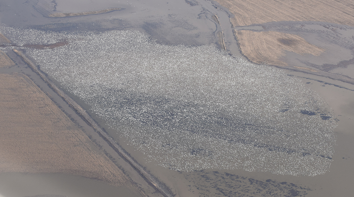
Geese are the only creatures that seem to appreciate all the flooded fields. Thousands of them have been spotted on the waters from I-29 west.

Rock Creek flooded last week, overflowing onto the walk bridge in Rock Port, covering a residential area, and flooding two vehicles owned by the Gutierrez family.

This photo (taken by Melissa Comstock) shows some cows stranded on a small patch of dry ground west of Craig on Hwy. 111, surrounded by miles of flooded farm ground. The cows’ owners are bringing them fresh hay every day.


